Beneath Africa’s vast landscapes, an extraordinary transformation is quietly progressing. In the heart of the east African rift, immense geological forces are slowly tearing the continent apart. This process signals the potential birth of a new ocean, a phenomenon that both fascinates and unsettles scientists worldwide. Although this event unfolds over millions of years, its eventual impact could profoundly reshape Africa and influence the future configuration of global geography.
What is happening in the east african rift?
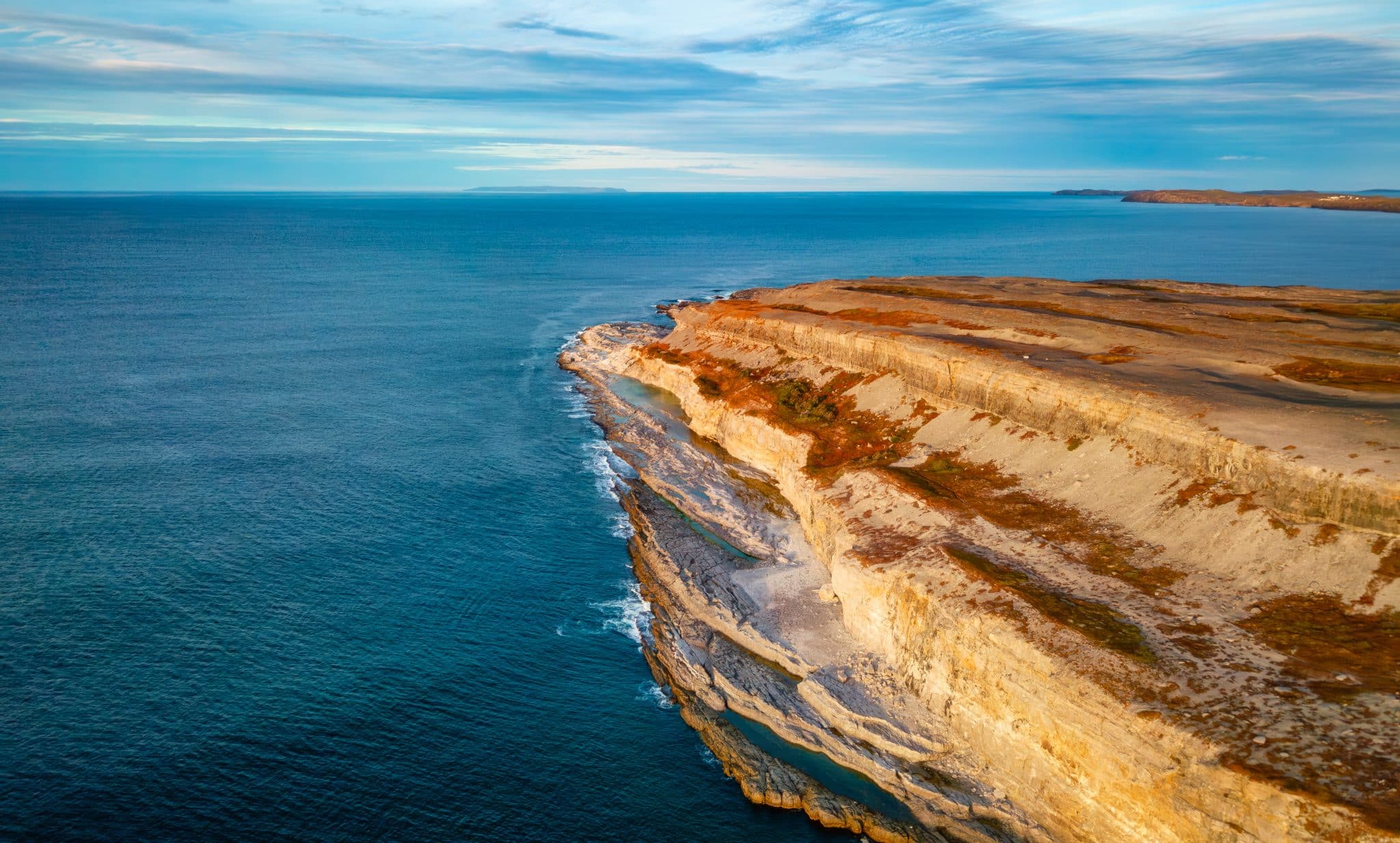
The east African rift stretches for about 4,000 kilometers from northern Ethiopia down to Mozambique, marking one of Earth’s most remarkable natural boundaries. Here, the African continent is gradually dividing as three major tectonic plates—the Nubian plate, the Somalian plate, and the Arabian plate—slowly drift apart. This ongoing tectonic plates movement creates visible faults and fissures across several nations, providing unmistakable evidence of powerful subterranean activity.
This process, known as continental rifting, involves the thinning and stretching of the earth’s crust over tens of millions of years. The Afar region, where these three plates converge, is particularly notable: the crust has become so thin that volcanic eruptions, deep valleys, and new lakes now emerge at the surface. For instance, discoveries such as the concentration of mineral deposits linked to ancient supercontinent cycles shed light on the influence of past geological events shaping our current landscape. These features serve as living proof of the continent’s gradual division and highlight the dynamic nature of our planet’s geology.
How does a new ocean start to form?
The slow separation between the Nubian and Somalian plates mirrors the ancient process that once led to the creation of the Atlantic Ocean. Scientists estimate that this new ocean formation began around 25 million years ago. Each year, the gap widens by roughly seven millimeters—a pace that seems negligible but is significant on a geological timescale. With continued movement, there is mounting evidence that this fractured landscape will eventually give rise to a brand-new marine basin.
In certain low-lying areas of the rift, water already seeps in, especially during periods of extreme weather. Over millions of years, it is expected that the Red Sea and the Gulf of Aden will gradually extend further inland, ultimately forming a continuous oceanic channel. Interestingly, similar geological changes have contributed to massive mineral accumulations elsewhere in the world, underlining the importance of supercontinent cycles in concentrating resources. As this process continues, the Horn of Africa will detach completely, leading to the opening of a vast body of water reminiscent of today’s Atlantic or Indian oceans.
Visible signs on the surface
Visitors traveling through the Rift Valley can observe dramatic evidence of the underlying tectonic activity. Cracks that split roads, wide chasms disrupting villages, and active volcanic cones all point to the restless movement below. Some fissures have grown large enough to swallow vehicles or divide fields, prompting ongoing monitoring by local authorities and scientific teams eager to study these changes firsthand.
Frequent minor earthquakes ripple through the region, while volcanoes like Erta Ale and Ol Doinyo Lengai dominate the horizon, acting as visible reminders of the potent forces at work. These striking surface features offer unique insights into the way continents may eventually split and redefine the world’s map over time.
Long-term outlook on oceanization
Despite the dramatic landscape, the full transformation into an ocean remains far in the future. At the current rate of movement, experts believe several million more years will pass before seawater fully inundates the area. Until then, shifting landforms and increasing volcanic activity will continue to shape both ecosystems and human communities within the rift.
This slow evolution turns the region into a natural laboratory for studying geological phenomena such as plate tectonics in real time. By observing these processes, researchers gain valuable knowledge about Africa’s changing face and broader patterns of planetary change.
Why are scientists concerned?
While the idea of continents drifting apart may seem distant, scientists’ concerns are grounded in very real risks. Major cities and agricultural zones often lie near these shifting regions, leaving communities vulnerable to dangers like earthquakes and ground subsidence. As the crust thins and fractures, infrastructure can be destabilized without warning, causing disruptions to daily life and economic activities.
Active volcanism adds another layer of uncertainty, with new vents or eruptions threatening transportation networks, homes, and essential services. Changes to river systems, which many local populations rely on, can occur suddenly as the land shifts. The complex intersection of human development and raw geological energy demands careful planning and constant vigilance from scientists and policymakers alike.
Exploring the impact on surrounding environments
The habitats along the east African rift are home to a remarkable variety of wildlife, including elephants roaming grasslands and distinctive fish species inhabiting rift lakes. As the land transforms, new ecological niches form, yet migratory routes and food sources may be disrupted. Volcanic ash alters soil composition, and rising lakes or emerging hot springs influence both animal life and agriculture for local residents.
Communities continually adapt to these environmental changes. Traditional building methods evolve to withstand tremors, while disaster preparedness becomes an integral part of daily life. Many nations collaborate with international organizations to share data, enhance monitoring technologies, and develop strategies for long-term adaptation and risk reduction.
- The spread of fissures can quickly and unexpectedly damage property and farmland.
- Frequent minor seismic events raise concerns about the possibility of larger earthquakes in the future.
- Expanding lakes have the potential to displace entire communities over time.
- Changes to drainage patterns may render previously fertile land unsuitable for farming.
What lessons does the east african rift offer for understanding Earth?
The unfolding story of the eastern African rift provides invaluable perspective on how planets change. Documenting each stage of continental rifting and tectonic movement here allows scientists to better understand the origins of major ocean basins worldwide. Field studies, mapping, and remote sensing refine models that explain how continents drift over time.
Insights gained from this region contribute to improved hazard mitigation strategies globally, fostering greater international scientific cooperation. Understanding one of the world’s largest geological laboratories helps reveal what might happen in other dynamic regions in the centuries or millennia ahead. Though imperceptibly slow on a human timescale, Africa’s transformation promises to redraw maps, coastlines, and histories in ways both profound and enduring.